Introduction
Geoconservation and the recognition of geosites of scientific and cultural importance have emerged as globally significant topics, marking a crucial point in the conservation of natural heritage and the promotion of responsible tourism (Brocx & Semeniuk 2007; Brilha 2018). Protecting these places not only contributes to preserving biodiversity and natural landscapes but also offers valuable opportunities for sustainable education and recreation for communities and tourists. Additionally, the recognition and conservation of geosites play an essential role in promoting the cultural identity and traditional heritage of a region, contributing to supporting local communities and stimulating sustainable economic development (Erikstad 2013; Fauzi & Misni 2016; Gordon 2018).
The region of the Călimani Mountains is deeply rooted in the history and geography of Romania (Cioanca & Bâca 2017), representing a place with remarkable geological and cultural diversity (Dincă 2004; Chifu 2006; Danila 2007; Cenusa 2010; Florea 2017; Szakács & Chiriță 2017). Despite their rich natural and artificial geosites, many remain undiscovered, unidentified, or unprotected. These geosites hold not only scientific importance but also significant educational and touristic value, with the potential to contribute substantially to the sustainable development of the region and the conservation of its natural and cultural heritage (Romsilva 2022).
In a field rich in varied evaluation methods such as those proposed by Reynard (2007), Brilha (2016), Warowna et al. (2016), and others (Amiri et al. 2018; Dowling & Newsome 2006; Errami et al. 2015; Cayla et al. 2016; Reynard & Brilha 2018; Selmi et al 2019; Gray & Crofts 2022; Gordon 2021, we have chosen to give special attention to the Pralong (2005) Method.
The Romanian literature consists primarily of regional studies that evaluate geomorphosites in various parts of the nation, including the Viștea glacial valley in the Făgăraș Mountains (Comănescu et al. 2011), the Ponoare protected area (Comănescu et al. 2012), the Bucegi Mountains (Comănescu et al. 2013), the Cozia Massif, Romania (Ovreiu et al. 2019), the Trascău Mountains (Cocean 2011), Măcin Mountains geopmorphosites (south-eastern Romania) (Gavril & Anghel 2013), Harghita Mountains geomorphosites (Rus 2018), the Danube Defile (Grecu & Iosif 2014), the Dobrogea Plateau (Rădulescu & Grecu 2018), glacial and periglacial landforms in the southern Carpathians, which emphasizes the diversity of geomorphology (Comănescu et al. 2019), the paleontological significance of the Canaralele geosite in Hârșova Port (Dumitraș et al. 2019), the scientific importance and ecotourism potential of the Hârșova Abator Quarry (Macovei et al. 2020), the sustainability of relief at geomorphosites from a tourism perspective, and the investigation of the potential and utilization of geomorphosites in the Baiului Mountains (Barbălată & Comănescu 2021), and the compilation of geosites, geomorphosites, and elements of geodiversity and biodiversity in the Putna River Basin (Necula et al. 2022). By comparison, the literature on the geomorphology of the Călimani Mountains is limited.
The exploration and identification of geosites in the Călimani Mountains region represent a significant opportunity for the development of a new UNESCO Geopark in Romania, the third in the country after Țara Hațegului and Buzău Land. Situated near the national tourist resort Vatra Dornei, known as the "Pearl of Bucovina," this area has vast potential (Chiriţă et al. 2015). Here, spectacular nature harmoniously intertwines with the historical and cultural heritage, showcased by numerous architectural monuments from the era of Emperor Franz Joseph and historic churches (Chiriţă et al. 2015).
Many of the mentioned geosites were discovered during field research, and subsequently, we learned about the local legends surrounding them. This emphasizes that not all of these geosites are natural reserves or well-known areas. The methodology for analyzing geosites proposed by Pralong has been adapted to fit the specific landscape of the Călimani Mountains. Here we describe the criteria and evaluations applied to the geosites in the region, highlighting their importance and the need for their protection through integration into the Călimani Mountains and the extension of the boundaries of the Călimani National Park. This marks the first step in identifying and analyzing geosites, contributing to the conservation and promotion of the natural and cultural heritage of the Călimani Mountains region.
Characteristics of the Study Zone
The Călimani Mountains belong to the volcanic chain covering the inner side of the Eastern Carpathians, situated at the junction of folded mountains with the major collapse depressions of Transylvania and Pannonia (Seghedi & Szakacs 1997; Stoica 2007) (Fig. 1). This area, including Căliman (Gurghiu and Harghita), represents the southern group of the youngest mountains in Romania, with now-extinguished craters formed approximately 1.8–5 million years ago, during the upper Pliocene and lower Pleistocene (Szakács & Seghedi 1997). Intense volcanic activity in the Neogene led to the formation of extensive lava deposits, stretching over a distance of 450 km (375 km within Romania) (Seghedi et al. 2005). The Călimani Massif, composed of alternating layers of lava, conglomerates, and ash (stratovolcano), is part of the southern group, representing the most significant volcanic mass with an area of approximately 6,400 km², a width of about 40 km (over 50 km in the Căliman sector), and a length of nearly 160 km (Seghedi et al. 2005). This massif stands out through its highest peaks (Pietrosul Călimanului - 2100 m, Bistricior - 1990 m, Gurghiu - 1776 m, Harghita - 1800 m), gradually descending towards Tușnad (Ciomatu - 1,301 m) (Seghedi et al. 2005; Stoica 2007). In this region, a significant number of partially eroded volcanic cones are observed, especially through collapses that led to the opening of immense craters (calderas) with a diameter of about 10 km in the Călimani region (Naum & Butnaru, 1988).
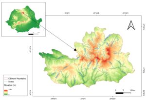
Figure 1. Geographical localization of the Călimani Mountains.
The name "Călimani Mountains" according to legend comes from a local shepherd named Căliman, whose legendary herds grazed these lands since ancient times (Introduction to the Fascinating World of the Romanian Carpathians 2022). This shepherd remained in the collective memory of the inhabitants, and his name has been associated over time with this beautiful and imposing mountainous massif. The legend and pastoral story have been passed down from generation to generation, becoming an integral part of the local identity and cultural ethos of this region.
The Călimani National Park represents a conservation area of national interest, classified as IUCN Category II (national park, special conservation area). It spans the central-northern part of Romania, covering the administrative territories of Mureș, Suceava, Harghita, and Bistrița-Năsăud counties (Romsilva 2022). Initially proposed in 1975, its protected area status was officially established by Law No. 5 of March 6, 2000, which approved the National Territorial Planning - Section III - protected areas (Romsilva 2022). In 2003, through Government Decision No. 230 of March 4, the boundaries and surface of the park were defined, solidifying the commitment to the conservation of natural resources and biodiversity in this significant region (Romsilva 2022). Despite its protected area status, the Călimani National Park does not cover the entire Călimani Mountains, a limitation in its protection and conservation. This highlights the necessity and opportunity to expand protected areas to include all significant elements of this valuable mountain habitat.
Methodology for Geosite Assessment
The identification and evaluation of geosites in the Călimani Mountains region were carried out through a combined approach, starting with preliminary identification using satellite imagery and GIS techniques. This phase was followed by extensive field investigations, involving direct exploration of the terrain to confirm and characterize the geosites in detail. To gain a comprehensive understanding of the significance of geosites in the region, information from multiple sources was integrated, including oral traditions passed down by locals, written sources such as books and historical documents, as well as information available on the internet. This holistic approach allowed for the delineation of a complete picture of the geosites, highlighting their deep connections to the history and culture of the region. We prefer the term "geosite" over "geomorphosite" for its broader connotations and its ability to encompass a variety of features, including cultural and landscape aspects, in addition to geomorphological ones (Pasquaré Mariotto et al. 2023).
Călimani Mountain has been selected to become a potential UNESCO Volcanic Geopark. Natural processes, such as wind and rain erosion, have contributed to shaping the terrain, and some geosites have also been influenced by human intervention, such as the sulfur mining that took place during the communist period (Naum & Butnaru 1988).
Sulfur mining in the Călimani Mountains, conducted between 1969 and 1997, had significant consequences on the surrounding environment (Naum & Butnaru 1988; Stoica 2007). Today, mining and its continued effects pose a threat to the biodiversity and natural landscape of the area (Danila 2007). The establishment of the Călimani National Park in 2000 represented a significant step towards the protection and conservation of this region (Romsilva 2022). However, there are still persistent ecological issues, including the degradation of forest and aquatic ecosystems, as well as ongoing threats to local fauna caused by previous mining activities.
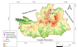
Figure 2. Distribution of Geosites in the study area.
Exploring the geosites in the Călimani Mountains area has led to the identification of no fewer than 34 points of geological interest (Fig. 2). For this research, we focus on five of these geosites, selected for their exceptional connections to local traditions, legends, and folklore. This strategic selection highlights aspects of cultural and natural heritage that have the potential to significantly contribute to the development of a future UNESCO volcanic geopark in the Călimani Mountains region.
For geosite evaluation, we use the method developed by Pralong (2005), adapted to reflect the specific characteristics of the Călimani Mountains and their geographic context. The choice of the Pralong method was motivated by its effectiveness and relevance in evaluating mountain geosites in Romania, as well as its adaptability to existing shortcomings in the fields of tourism and nature conservation (Cocean 2011; Toma 2012; Rus 2018).
The assessment is based on a well-defined list of criteria, utilizing a rating scale from 0 to 1, including intermediate values (0.25, 0.50, 0.75), for each considered parameter (Table 1). Intermediate values in the evaluation table reflect the degree to which each geosite meets the criteria.
Table 1. Results from evaluating the geosites according to the Pralong Method. G1, The Sphinx of Colibița; G2, Pintea's Palm; G3, Engraved Megalith; G4, Tătarului Rocks.
Categories | Parameters | G1 | G2 | G3 | G4 |
Geomorphological value | Genesis | 1 | 0.25 | 0.5 | 1 |
Dynamics | 0.5 | 0.5 | 0.5 | 0.5 | |
Diversity of elements of interest | 1 | 1 | 1 | 1 | |
Integrity | 0.75 | 1 | 0.75 | 1 | |
Rarity | 0.75 | 1 | 1 | 0.75 | |
Aesthetic value | Physiognomy | 0.75 | 0.25 | 1 | 0.75 |
Chromatics | 0.5 | 0.5 | 0.25 | 1 | |
Vertical development | 1 | 1 | 1 | 1 | |
Attractiveness of the landscape | 0.75 | 0.25 | 1 | 1 | |
Visibility | 1 | 0.5 | 0.25 | 1 | |
Ecological Value
| Flora and Fauna | 1 | 0 | 0 | 1 |
Protection | 1 | 1 | 1 | 1 | |
Scientific and Cultural Value | Scientific representativeness | 1 | 0.25 | 0.75 | 0.75 |
Representativeness of geomorphological processes | 1 | 1 | 0.5 | 1 | |
Paleogeographical and formative interest | 1 | 1 | 1 | 1 | |
Cultural value | 1 | 1 | 1 | 1 | |
Touristic value | Number of possible activities | 0.5 | 0.75 | 0.75 | 1 |
Accessibility | 1 | 0.5 | 1 | 0.5 | |
Relationship with the polarizing centers | 0.25 | 0.5 | 0.25 | 1 | |
Socio-economical characteristics of the neighboring region | 0.25 | 0.25 | 0.25 | 0.25 | |
Potential for tourism development | 1 | 1 | 1 | 1 | |
Touristic infrastructure | 0.25 | 0.25 | 1 | 0.25 | |
Stage of current tourism exploitation | 1 | 0.5 | 0.5 | 0.5 | |
Restrictive attributes | Vulnerability to natural processes | 0.25 | 0.25 | 0.25 | 0 |
Anthropogenic activities | 0 | 0 | 0.25 | 0 | |
Unesthetic elements | 0 | 0 | 0 | 0.5 |
Geomorphological Value
• Genesis: The degree of complexity and involvement of morphogenetic factors in the formation of the geosite.
• Dynamics: Evaluation of the dynamics and changes that have occurred in the assessed relief.
• Diversity of notable features: The number and variety of geomorphologically notable elements.
• Integrity: The conservation status of geomorphological forms.
• Rarity: The degree of uniqueness of the geosite in a regional and national context.
Aesthetic Value
• Physiognomy: The appearance and presence of the physical uniqueness of the geosite.
• Chromatics: The variation and aesthetic pleasure of the present colors.
• Vertical development: The difference in altitude and its impact on visual appearance.
• Landscape attractiveness: The ability to attract and captivate the observer.
• Visibility: The degree of exposure and visibility of the geosite.
Ecological Value
• Flora and Fauna: The rarity and importance of present plant and animal species.
• Protection: The degree of conservation and protection of the natural environment.
Scientific and Cultural Value
• Scientific representativeness: Importance and relevance in scientific research.
• Representativeness of geomorphological processes: The degree of exemplification of processes and pedagogical interest.
• Paleogeographic and formative interest: Importance in the paleogeographic context and its formative capacity.
• Cultural value: Relevance in the historical, archaeological, religious, artistic, and associated manifestations context.
Touristic Value
• Number of possible activities: Diversity of possible tourist and recreational activities.
• Accessibility: The ease of accessing the geosite.
• Relationship with polarizing centers: Distance from urban and attractive centers.
• Socio-economic features of the surrounding region: The socio-economic context of the surrounding area and its relationship with the geosite.
• Potential for tourist exploitation: Attractiveness at the international, national, and regional levels.
• Touristic infrastructure: Availability and quality of associated tourist infrastructure.
• Stage of current tourist exploitation: The degree and duration of tourist exploitation of the geosite.
Restrictive Attributes (restrictive values) This category evaluates characteristics that can limit or affect the value and integrity of the geosite.
• Vulnerability to natural processes: Evaluation of the geosite's risk degree regarding natural processes (such as erosion, landslides, climatic phenomena, etc.).
• Anthropogenic activities: Evaluation of the degree of human activities influence on the geosite.
• Inesthetic elements: Evaluation of the presence or absence of elements affecting the aesthetic aspect of the geosite.
New Geosites Proposed for Geoheritage
G1 – The Sphinx of Colibița, a natural geosite, rock formation
Coordinates: 47°10'32.132"N, 24°49'43.968"E
The rock outcrop in Colibița, referred to as the 'Sphinx of Colibița,' represents a distinctive geological feature situated in the Bistrița Mountains region, Bistrița-Năsăud County (Fig. 3). This geological formation, exhibiting a semblance to a sphinx, is an outcome of natural processes of erosion and lithogenic sculpting over a geological period (Ministry of Environment 2016). Meteorological phenomena, including rainfall, wind action, and freeze-thaw cycles, have played a pivotal role in delineating and sculpting this unique form.
Figure 3. Sphinx of Colibița, personal photo.
G2 – Pintea's Palm, a natural geosite, rock formation
Coordinates: 47°14'07.16''N, 25°13'59.97''E
The name Pintea derives from the renowned outlaw Pintea the Brave, a former celebrated outlaw from Măgoaja, Țara Lăpușului ('Divine Punishments and Inscriptions of Thousands of Years. The Legends of the Călimani Mountains,' 2019) (Fig. 4A). According to legends, he engaged in conflicts with the nobility and decided to fight against the injustices of that time. He became well-known in the forests of Maramureș, continuing his 'outlaw' activities. According to the legends, Pintea managed to escape every time the nobility attempted to capture him. The toponyms in Călimani ('Pintea's Spring' and 'Pintea's Palm') add an intriguing historical aspect to this geosite, as this territory was extensively traversed by the real Pintea ('Călimani National Park Border Between Transylvania, Bucovina, and Moldova ~ Călimani National Park (Țara Dornelor (Dornelor Land)),' 2011). Pintea's Palm is located in Cold Water (translated Apa rece), accessible through existing trails in the Călimani Massif throughout all seasons (Fig. 4B). Thus, this geosite endures in history not only for its local legend but also for the peculiar symbols on the rock—ancient symbols from the Dacian period (Fig. 4C). Unfortunately, these symbols have not been analyzed by archaeologists. Although the symbols have been engraved on the rock a long time ago, they lack protection, and many passers-by overlook them as they head towards the natural reserve known as the Twelve Apostles, a protected area and a natural monument. The lack of interest can be attributed, in part, to the lack of promotion and recognition. With more intense promotion, we hope to generate greater interest and encourage the conservation and understanding of this important symbol of local history.
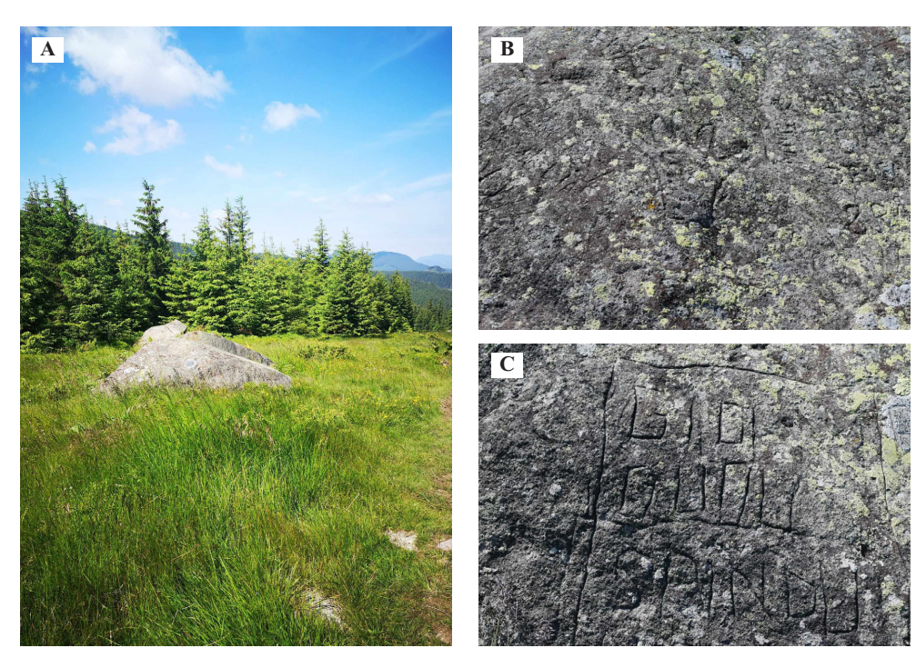
Figure 4. A) Geosite localization: Pintea's Palm; B) Pintea's Palm impression on the geological formation; C) inscriptions and markings on the geological formation.
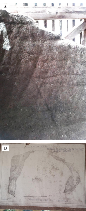
Figure 5. A) Engraved megalith with enigmatic engravings; B) engraved megalith map with enigmatic symbols representing the geosite associated with sun cult symbolism.
G3 – Engraved Megalith, rock formation
Coordinates: 47°11'41.503"N, 25°15'24.156"E
Megaliths were unearthed here with unprecedented symbols and inscriptions (Fig. 5A). They were found in 1987 when Claudiu Pata from Gura Haitii found a stone with enigmatic engravings and symbols in a 2-meter-deep trench (Naum & Butnaru 1988). Specialists have traced the origin of the rocks to around 4,000 BCE, with inscriptions resembling the letters of the Getae alphabet and solar symbols akin to those found in ancient cultures (Fig. 5B). Some theories and interpretations suggest a possible connection between these megaliths and the Pelasgian culture, yet these claims are subject to debate and haven't been definitively confirmed by the academic community ('The Mysteries of the Megaliths or the Path of the "12 Apostles" in the Călimani Mountains,' 2018).
Figure 6. Tătarului Rocks, personal photo.
G4 – Tătarului Rocks, natural geosite, rock formations
Coordinates: 47°09'33.022"N, 24°48'22.083"E
Tătarului Rocks is a volcanic geosite located in the eastern part of Bistrița-Năsăud County, within the administrative territory of Bistra Bârgăului commune (Fig. 6). It is recognized as a natural (landscape) reserve of national interest, included in category IV of the IUCN by Law No. 5 dated March 6, 2000, covering an area of 25 hectares (Ministry of the Environment 2016). The geosite's name "Tătarului Rocks" comes from the term "Tătarcă" or "Tătar Cliff" (Ministry of the Environment 2016). The relief of the area is diverse, consisting of rock formations, clearings, and cliffs. The slopes are covered with deciduous forests mixed with spruce. Legend has it that on a day of Sânziene (Midsummer) when the Tătars invaded from the south, a tall column of smoke in the sky warned the people of danger. The inhabitants hid, and the girls lured the invaders. When the Tătars were intoxicated, the young men rolled large rocks over them. The story has been passed down through history, and the legend speaks of a mound near Tătarca Valley, where it is presumed that the Tatars and their war booty are buried. This place is considered cursed, and anyone attempting to dig risks something bad happening (Ministry of the Environment 2016).
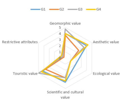
Figure 7. Radar graphic with results using the Pralong method. G1 – The Sphinx of Colibița, G2 – Pintea's Palm, G3 – Engraved Megalith, G4 – Tătarului
Results and Discussion
We evaluated these proposed geosites using the criteria of the Pralong Method (Table 1). The numerical values reflect the geomorphological, aesthetic, ecological, scientific, cultural, and touristic values of each geosite. We further analyze the key points highlighted by these evaluations and explore their impact on our proposal for the expansion of the Călimani Mountains National Park as a potential UNESCO Geopark.
The radar chart (Fig. 7) provides a clear visual representation of the evaluations given to geosites in various categories. Each category is represented on the radial axes, and the points on these axes indicate the level of the evaluation assigned to each geosite. The closer a point is to the edge of the chart, the higher the evaluation in that category.
The Sphinx of Colibița (G1) stands out by its high geomorphological value, resulting from distinctive rock formations and natural processes that led to the creation of this formation. Its aesthetically pleasing appearance, resembling a sphinx, adds a unique touch. It is protected from anthropogenic activities and does not present significant restrictive attributes. The name "Sphinx of Colibița," coined by me, stems from a visual comparison, highlighting its resemblance to the famous Egyptian Sphinx. This association is based on the remarkable aesthetic impact of the formation, visible from a distance, reminiscent of the presence and mastery of the Egyptian Sphinx. However, it is crucial to emphasize that this comparison pertains solely to visual appearance and does not indicate any historical or cultural connection. The Sphinx of Colibița is the result of natural processes such as erosion and rock shaping over geological time, adding uniqueness and geomorphological value.
Pintea`s Palm (G2) adds geomorphological value to the landscape, associated with the legendary outlaw Pintea the Brave and its connection to regional history. Aesthetic attributes are supported by local legends. Its year-round accessibility makes this geosite a tourist attraction, and the absence of significant restrictive attributes recommends it for exploitation. While overt restrictive attributes such as vandalism or anthropogenic degradation may be absent, it is imperative to address potential threats to the geosite Pintea's Palm, including its neglect or lack of awareness regarding its cultural and geological significance. Thus, proactive measures are warranted to safeguard and preserve this geosite over time.
The Engraved Megalith (G3 stands out for its remarkable geomorphological value, given by the symbols and enigmatic inscriptions. Its scientific relevance is supported by similarities with the letters of the Getic alphabet. However, contentious aspects, such as association with the Pelasgian culture, may provoke debate and necessitate vigilant management. The geosite represents a significant discovery with profound geomorphological and scientific implications. To ensure the conservation and protection of this unique geosite, appropriate geosite development and the implementation of enhanced security measures are recommended. These actions would include, among others, proper signage, protective barriers, and constant monitoring to prevent acts of destruction or vandalism. Furthermore, the construction of a museum is proposed to facilitate future scientific research and promote education in the field of cultural and archaeological heritage.
The Tătarului Rocks (G4) stand out for their geomorphological value as a volcanic geosite, included in IUCN Category IV. The legend and historical connotations add uniqueness and tourism potential. The idea of a curse serves more as a concept for the protection of the area. The Tătarului Rocks (G4) received low scores for unattractive elements, attributed to the presence of household waste. This issue can impact not only the aesthetics but also the ecological integrity of these places, requiring management and educational measures. Geosites that scored in terms of vulnerability to natural processes may be exposed to the risk of deterioration from factors such as erosion, heavy precipitation, and strong winds. These natural phenomena can affect the integrity and aesthetics of these geosites, emphasizing the need for effective management and protection strategies.
All these geosites have significant values, but G1 and G4 stand out for their geomorphological value, G2 for their cultural and touristic value. G3 makes a distinct contribution at the scientific level. The proposal for the protection and expansion of the Călimani Natural Park could benefit from specific approaches for each geosite.
Conclusion
The study of geosites in the Călimani Mountains area makes an essential contribution to understanding the complex geological and cultural landscape of the region. The assessment reveals remarkable diversity and significant potential of these geosites in terms of geomorphological, aesthetic, ecological, scientific, cultural, and touristic values. Each geosite is distinguished by unique geological features and historical events that contribute to the rich natural and cultural heritage of the area. However, identifying certain restrictive attributes, such as vulnerability to natural processes or the presence of unaesthetic elements, emphasizes the need for carefully designed management strategies to protect and sustainably conserve these geosites.
A pivotal proposal emerging from our findings involves the expansion of the Călimani Natural Park to encompass these geosites and the subsequent designation as a UNESCO Geopark, focusing on the region's volcanic heritage. This transformative initiative promises to enhance biodiversity, cultural appreciation, and scientific inquiry while fostering responsible tourism and community engagement.
Our study represents a foundational step toward shaping inclusive conservation and sustainable development policies for the geological and cultural heritage of the Călimani Mountains. By embracing an integrated approach and fostering collaborative stewardship, we can ensure that these geosites serve as enduring symbols of our shared natural and cultural legacy.
Conflict of Interest
There are no conflicts of interest related to the research presented in the article.
References
Amiri M, Nohegar A, Bouzari S (2018). Potential Assessment of Geomorphological Landforms of the Mountainous Highland Region, Haraz Watershed, Mazandaran, Iran, Using the Pralong Method. Pollution. 4: 381–394. https://doi.org/10.22059/poll.2018.240018.302
Barbălată (Alb) L, Comănescu L (2021). Environmental Sustainability and the Inclusion of Geomorphosites in Tourist Activity - Case Study: The Baiului Mountains, Romania. Sustainability. 13: 8094. https://doi.org/10.3390/su13148094.
Brilha J (2016). Inventory and Quantitative Assessment of Geosites and Geodiversity Sites: A Review. Geoheritage. 8: 119–134. https://doi.org/10.1007/s12371-014-0139-3
Brilha J (2018). Geoheritage. In Geoheritage (pp. 69–85). Elsevier. University of Minho, Braga, Portugal. https://doi.org/10.1016/B978-0-12-809531-7.00004-6
Brocx M, Semeniuk V (2007). Geoheritage and Geoconservation – History, Definition, Scope and Scale. Journal of the Royal Society of Western Australia. 90: 53–87.
Cayla N, Gauchon C, Hobléa F (2016). From Tourism to Geotourism: A Few Historical Cases from the French Alpine Foreland. Geological Society, London, Special Publications, 417: 199–213. https://doi.org/10.1144/SP417.10
Cenusa E (2010). Research on the Establishment of Natural Vegetation in Areas Affected by Mining Activities in the Călimani National Park. Ministry of Education, Research, Youth, and Sports; Transylvania University of Brașov.
Chifu T (2006). The Limit Spruce Forest (Cembreto-Piceetum abietis) in the Călimani Mountains. Annals of the University "Al. I. Cuza" from Iași, Geography Series.
Chiriță V, Lupchian M-M, Matei D (2015). The Vatra Dornei Tourism Development Through Local Entrepreneurship (Romania). GeoJournal of Tourism and Geosites, 8: 206–216. http://gtg.webhost.uoradea.ro/
Cioanca L-M, Bâca I (2017). Geosites with Cultural-Historical Significance for the Communities in the Bârgău Valley. Case study: The Monument of the Heroes from Grujul Mare (1882 m) in the Călimani Mountains. Bârgăuan Yearbook, 7, 2017, Ed. Școala Ardeleană, Cluj-Napoca.
Cocean G (2011). The Relationship Between Relief and Tourism in the Trascău Mountains. Facultatea de Geografie pp. 1–34) Cluj.
Comănescu L, Nedelea A, Dobre R (2011). Evaluation of Geomorphosites in Vistea Valley (Fagaras Mountains-Carpathians, Romania). International Journal of Physical Sciences, 6: 1161–1168.
Comănescu L, Nedelea A, Dobre R (2012). The Evaluation of Geomorphosites from the Ponoare Protected Area, Forum Geografic. 11: 54–61.
Comănescu L, Nedelea A, Dobre R (2013). The Geotouristic Map - Between Theory and Practical Use. Case Study - The Central Sector of the Bucegi Mountains (Romania). Geo-Journal of Tourism and Geosites. 11: 16–23.
Comănescu L, Nedelea A, Stănoiu G (2019). Geomorphosites and Geotourism in Bucharest City Center (Romania). Quaestiones Geographicae. 36: 51–61. Doi: 10.1515/quageo-2017-0029;
Danila EL (2007). Innovation and Entrepreneurship in Călimani National Park; University “Stefan cel Mare” Suceava.
Dincă I (2004). Water and Landscapes in the Călimani Mountains. University of Oradea Publishing House, Oradea.
Divine Punishments and Inscriptions of Thousands of Years. The Legends of the Călimani Mountains." (2019, January 14). eMunte.ro. https://www.emunte.ro/pedepse-divine-si-inscriptii-de-mii-de-ani-legendele-muntilor-Călimani/
Dowling RK, Newsome D (Eds.). (2006). Geotourism. Elsevier.
Dumitraș DG, Grigore D, Perșa D, Abioui M (2019). Geosite of the Month 'Canaralele din Portul Hârșova'-The Paleontological Importance of the Most Complete Oxfordian Geosite in Central Dobrogea, Romania. Geoconservation Research, 2: 40–44. 10.30486/gcr.2019.1878598.1014;
Erikstad L (2013). Geoheritage and Geodiversity Management – the Questions for Tomorrow. Proceedings of the Geologists’ Association, 124: 713–719. https://doi.org/10.1016/j.pgeola.2012.07.003
Errami E, Brocx M, Semeniuk V (Eds.). (2015). From Geoheritage to Geoparks: Case Studies from Africa and Beyond. Springer International Publishing.
Fauzi NSM, Misni A (2016). Geoheritage Conservation: Indicators Affecting the Condition and Sustainability of Geopark – A Conceptual Review. Procedia - Social and Behavioral Sciences. 222: 676–684. https://doi.org/10.1016/j.sbspro.2016.05.224
Florea L (2017). The Inventory of Fish from the National Park Călimani: Pressures, Threats, and Management Directions. Current Trends in Natural Sciences, 6: 174–183.
Gavril IG, Anghel T. (n.d.). Geomorphosites inventory in the Măcin Mountains (south-eastern Romania). Babeş-Bolyai University, Faculty of Geography, Cluj Napoca.
Gordon J (2018). Geoheritage, Geotourism and the Cultural Landscape: Enhancing the Visitor Experience and Promoting Geoconservation. Geosciences. 8: 136. https://doi.org/10.3390/geosciences8040136
Gordon JE, Crofts R, Gray M, Tormey D (2021). Including geoconservation in the management of protected and conserved areas matters for all of nature and people. International Journal of Geoheritage and Parks. 9: 323–334. https://doi.org/10.1016/j.ijgeop.2021.05.003
Gray M, Crofts R (2022). The potential role of the geosciences in contributing to the UN’s sustainable development goals. Parks Stewardship Forum 38(1). https://doi.org/10.5070/P538156120
Grecu F, Iosif D (2014). La Notion du Géosite et son Pertinence dans une Étude sur la Région des Gorges du Danube en Roumanie, Analele Universităţii Bucureşti: Seria Geografie 63: 178–184.
Introduction to the Fascinating World of the Romanian Carpathians - Part VII: The Volcanic Triad - the Călimani, Gurghiu, Harghita Massifs." (March 9, 2022). "Traveler on the Paths of the Carpathians." Retrieved from: https://calatorpepotecilecarpatilor.blog/introducere/introducere-in-lumea-fascinanta-a-carpatilor-romaniei-partea-a-vii-a-triada-vulcanica-masivele-Călimani-gurghiu-harghita/
Macovei M, Danciu I, Sebe-Rădoi OG, Grigore D, Crușoveanu S. (2020) Preliminary Evaluation of the Abator Quarry - Hârșova (Romania) - A proposal for a New Geosite. Muzeul Olteniei, Craiova. Oltenia. Studii şi Comunicări. Ştiinţele Naturii. 36: 21–28.
Ministry of the Environment (2016). Integrated Management Plan for the Natura 2000 Site ROSCI0051 Cuşma.
Naum T, Butnaru E (1988). Monograph of the Căliman Mountains. Sport and Tourism Publishing House, Dolj.
Necula N, Mihai N, Vasiliniuc I (2022). Geosites, Geomorphosites and Geodiversity in Putna Catchment, Vrancea, Romania. EGU Conference Abstracts, EGU22-11182.
Ovreiu AB, Bărsoianu IA, Comănescu L, Nedelea A (2019). Capitalizing of the geotourism potential and its impact on relief. Case study: Cozia massif, Romania. Geo Journal of Tourism and Geosites. 24: 212–236.
Pasquaré Mariotto F, Drymoni K, Bonali FL, Tibaldi A, Corti N, Oppizzi P (2023). Geosite Assessment and Communication: A Review. Resources. 12: 29. https://doi.org/10.3390/resources12020029
Pralong J-P (2005). A Method for Assessing Tourist Potential and Use of Geomorphological Sites. Géomorphologie Relief Processus Environnement. 11: 189–196.
Rădulescu C, Grecu F (2018). L'Enquête Statistique sur la Relation entre Valeur Scientifique et la Valeur Globale des Géosites du Plateau d'Oltina, Cinq Continents. 8: 118–132.
Reynard E, Brilha J (2018). Geoheritage: a multidisciplinary and applied research topic. In Geoheritage (pp. 3-9). Elsevier, Amsterdam.
Reynard E, Fontana G, Kozlik L, Scapozza C (2007). A Method for Assessing Scientific and Additional Values of Geomorphosites. Geographica Helvetica. 62: 148–158. https://doi.org/10.5194/gh-62-148-2007
Romsilva (2022). Management Plan of Călimani National Park, the Site of Community Importance ROSCI0019 Călimani-Gurghiu (the Part Overlapping with Călimani National Park), the Special Protection Area ROSPA0133 Munții Călimani, and the Areas of National Interest that Overlap with It.
Rus O (2018). Geomorphosites in the Harghita Mountains. Babeș-Bolyai University, Cluj-Napoca, Faculty of Geography.
Seghedi I, Szakács A (1997). The Călimani-Gurghiu-Harghita (CGH) Volcanic Chain. In Field Trip Guide of 4th National Symposium on Mineralogy, 3-8 October 1997, Iaşi (pp. 14-19). Romanian Journal of Mineralogy. 78(Suppl. 2).
Seghedi I, Szakacs A, Pèkskay Z, Raul R, Mason D (2005). Eruptive Stages and Age of Magmatic Processes in the Călimani Volcanic Structure. Geologica Carpathica. 56: 67–75.
Selmi L, Coratza P, Gauci R, Soldati M (2019). Geoheritage as a Tool for Environmental Management: A Case Study in Northern Malta (central Mediterranean Sea). MDPI Journal. 8: 168. https://doi.org/10.3390/resources8040168
Stoica D-L (2007). Research on Physical Geography on the Northern Slope of the Călimani Massif. Terra Nostra, Iași.
Szakács A, Chiriță V (2017). Protected Natural Values of Geoheritage Interest in the Călimani National Park, Eastern Carpathians, Romania. Geoheritage. 9: 421–434. https://doi.org/10.1007/s12371-017-0230-7
The Mysteries of the Megaliths or the Path of the '12 Apostles' in the Călimani Mountains. (2018, November 28). Romania Cultural Magazine. Retrieved from https://culturaromana.ro/misterele-megalitilor-sau-poteca-celor-12-apostoli-din-muntii-Călimani/
Toma CB (2012). Geomorphosites on Salt in the Transylvanian Depression and Their Touristic Valorization [Doctoral dissertation, Babeș-Bolyai University, Faculty of Geography]. Cluj-Napoca.
Warowna J, Zgłobicki W, Kołodyńska-Gawrysiak R, Gajek G, Gawrysiak L, Telecka M (2016). Geotourist values of loess geoheritage within the planned Geopark Małopolska Vistula River Gap, E Poland. Quaternary International. 399: 46–57. https://doi.org/10.1016/j.quaint.2015.06.064
Welcome2Romania. (2011, October 6). Călimani National Park - The Border between Transylvania, Bukovina, and Moldova. Retrieved October 6, 2011, from https://welcome2romania.wordpress.com/2011/10/06/parcul-national-calimani-granita-intre-ardeal-bucovina-si-moldova-national-park-calimani/